Introduction
Before a leader makes a critical decision, whether navigating a complex global defense strategy or deploying emergency relief teams into an unfamiliar environment, establishing accurate knowledge of the terrain is essential. In the defense and security sectors, this foundational process is known as military reconnaissance—the systematic act of actively exploring an area to gather real-world facts and eliminate dangerous uncertainty. Today, platforms like WarOpsX.com highlight how these missions have evolved far beyond traditional conflict zones; they are now equally indispensable for orchestrating international peacekeeping efforts, navigating structural blockades during natural disasters, and maximizing public safety during humanitarian relief operations. By building reliable situational awareness from the ground up, reconnaissance serves as the vital link that protects personnel, optimizes limited resources, and ensures organizations can act with confidence and clarity.
What Is a Reconnaissance Mission?
Definition
At its most basic level, a reconnaissance mission (often called “recce” or “recon”) is a focused effort to gather primary information about an environment, an area, or a specific route. It is a visual and physical exploration designed to secure facts about a territory and the entities within it.
Purpose and Objectives
The main objective of a reconnaissance mission is to reduce uncertainty. By sending out observers—whether humans, drones, or satellites—an organization seeks to discover:
- The layout of the terrain and geography.
- The presence of obstacles like broken bridges or blocked roads.
- The location and strength of other forces or displaced populations.
Why It Matters
Without reconnaissance, leaders are essentially operating in the dark. It provides the ground truth required to make smart, ethical, and highly effective choices.
The Difference: Reconnaissance, Surveillance, and Intelligence
While people often mix up these terms, they actually mean different things within defense operations:
- Reconnaissance: This is a specific, active mission to go out and discover new information about a place or route. It has a clear start and end point.
- Surveillance: This is the continuous, systematic observation of a specific area, person, or place over a long period. Think of a security camera watching a gate for weeks; that is surveillance.
- Intelligence: This is the final product. Intelligence takes the raw facts gathered by both reconnaissance and surveillance, analyzes them, connects the dots, and explains what the data actually means for decision-makers.
Why Reconnaissance Matters
Understanding the environment saves lives and resources. Here are the core reasons why these information-gathering missions are indispensable:
- Better Situational Awareness: It helps teams understand the big picture. Knowing who is where, what the roads look like, and what hazards exist prevents costly surprises.
- Informed Decision-Making: Leaders do not have to guess. They can base their plans on real, verifiable facts brought back from the field.
- Risk Reduction: By identifying dangers early—such as a washed-out road or an ambush point—teams can avoid hazardous areas entirely.
- Resource Planning: If you know a route is muddy, you will send heavy-duty trucks instead of small cars. Reconnaissance tells you exactly what tools are needed.
- Mission Effectiveness: Whether delivering food supplies during a famine or protecting a border, knowing the layout ensures the job gets done right the first time.
- Public Safety During Humanitarian Operations: In natural disasters, reconnaissance identifies unstable buildings or rising floodwaters, keeping both rescue workers and civilians out of harm’s way.
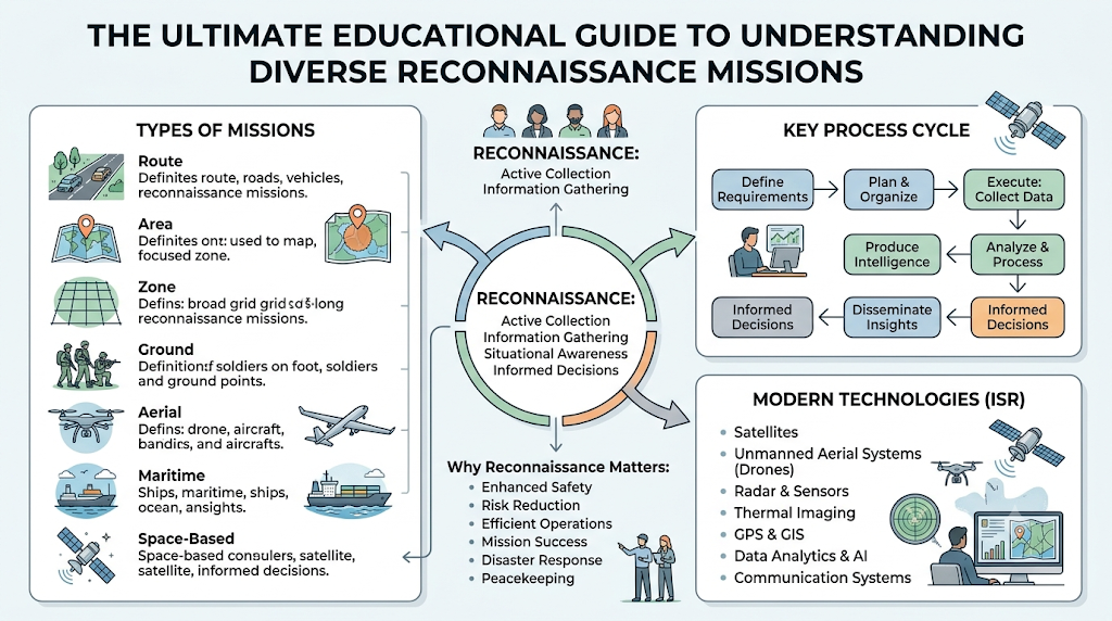
Types of Reconnaissance Missions
Different situations require different approaches to information collection. Here is a high-level look at the primary types of battlefield reconnaissance and environmental mapping:
Route Reconnaissance
This focuses entirely on a specific path of travel, such as a highway, a railway line, or a river route. The goal is to make sure vehicles can pass through safely without hitting unexpected roadblocks or natural hazards.
Area Reconnaissance
This type involves looking at a specific, distinct piece of land, such as a town square, a forest patch, or a valley. Teams focus on gathering information about every detail within those exact boundaries.
Zone Reconnaissance
Zone reconnaissance is much broader. It involves checking a wide, expansive geographical area with multiple moving parts. Teams systematically search through the entire zone to map out everything of interest.
Ground Reconnaissance
This is conducted by personnel directly on the earth’s surface. Using vehicles or walking on foot, scout teams observe the small, nuanced details of the terrain that might be missed from far away.
Aerial Reconnaissance
Conducted from the sky using airplanes, helicopters, or unmanned systems, this approach provides a bird’s-eye view of vast spaces very quickly.
Maritime Reconnaissance
Focused entirely on oceans, seas, and coastal regions, this type maps out water depths, searches for naval vessels, and monitors busy shipping lanes to keep trade routes safe.
Space-Based Reconnaissance
Utilizing advanced satellites orbiting the Earth, this method allows organizations to monitor massive global shifts, track major weather systems, and observe large-scale movements across continents.
Key Components of a Reconnaissance Mission
To understand how these missions function, it helps to look at them as a step-by-step cycle. We can use the simple analogy of a weather reporter to make these concepts easy to grasp.
- Information Requirements: This is the question you need answered. (Analogy: “Will it rain in the city tomorrow?”)
- Observation: The act of looking closely at the subject. (Analogy: The meteorologist looks at clouds and wind patterns.)
- Data Collection: Gathering physical proof and numbers. (Analogy: Recording the exact air pressure and temperature.)
- Communication: Sending the gathered data back to headquarters quickly and securely. (Analogy: Sending the weather readings to the TV studio via digital networks.)
- Reporting: Presenting the information clearly. (Analogy: Writing a clear, structured summary of the upcoming storm.)
- Analysis: Deciding what the facts actually mean. (Analogy: Realizing that the rain will cause a flash flood on Main Street.)
- Situational Awareness: The final state of complete understanding. (Analogy: The entire city now knows to stay indoors and avoid low-lying roads.)
Technologies Used in Modern Reconnaissance
In the past, reconnaissance relied purely on a pair of binoculars and a paper notebook. Today, modern technology has completely revolutionized the field of Intelligence, Surveillance, and Reconnaissance (ISR).
[Sensors/Satellites] ➔ [Data Fusion / AI Platform] ➔ [Clear Situational Awareness]
Satellites
High-tech cameras orbiting space can take incredibly detailed pictures of the earth below, providing massive strategic advantages without risking human lives.
Drones (Unmanned Aerial Systems)
Drones act as eyes in the sky for local teams. They can fly into dangerous or tight spaces—like a smoky forest fire or a damaged urban area—to stream live video back to operators.
Radar and Optical Sensors
Radar can “see” through thick fog, heavy rain, and darkness by bouncing radio waves off objects, mapping out the shape of the land when human vision fails.
Thermal Imaging
These specialized lenses detect heat instead of light. They allow rescue teams to find lost hikers at night by spotting their body heat against the cold ground.
GPS and Geographic Information Systems (GIS)
GPS provides exact coordinates down to the inch, while GIS software layers this data onto digital maps, making it easy to see patterns, hills, and valleys clearly.
Artificial Intelligence and Data Analytics
Modern sensors collect terabytes of data every single second. Artificial Intelligence helps sift through millions of photos and data points instantly to flag unusual changes, saving human analysts thousands of hours of manual work.
Benefits of Reconnaissance Missions
Investing time and energy into proper reconnaissance yields profound benefits across defense operations and civilian life:
- Better Planning: Gives planners accurate maps and facts so they don’t have to rely on guesswork.
- Faster Decision-Making: When accurate data is already on the screen, leaders can act immediately during crises.
- Improved Coordination: Allows multiple teams—like police, firefighters, and medical staff—to share the exact same view of the situation.
- Enhanced Safety: Keeps personnel out of unnecessary danger by identifying hazards before they arrive.
- Efficient Resource Management: Ensures expensive equipment and limited supplies are sent exactly where they will do the most good.
- Better Disaster Response: Allows emergency workers to quickly find open, unblocked roads to deliver medicine to survivors.
- Improved Environmental Monitoring: Tracks illegal logging, tracks wildlife poaching, and maps oil spills in the ocean to protect our planet.
Common Challenges
Gathering information is rarely easy. Teams face severe real-world challenges that can disrupt a mission:
- Difficult Terrain: High mountains, dense jungles, and thick swamps make it physically tough for ground teams to move or see clearly.
- Weather Conditions: Heavy snow, thick dust storms, and torrential downpours can blind aerial drones and block satellite lenses.
- Information Overload: Having too many cameras and sensors can flood headquarters with thousands of hours of video, making it hard to find the truly important details.
- Communication Challenges: Deep valleys, solar flares, or underground structures can completely block radio and satellite signals.
- Data Accuracy: False leads, outdated maps, or confusing visual reflections can trick observers into making incorrect assumptions.
- Technology Limitations: Batteries die, drones malfunction, and software crashes, reminding us that hardware is never foolproof.
- Ethical and Legal Considerations: Balancing national security with privacy rights and respecting international borders are critical dilemmas that modern organizations must carefully navigate.
Historical and Modern Examples
Looking back at history helps us see how reconnaissance principles work in practice.
World War II (The Battle of Britain)
During this massive conflict, the early use of radar technology functioned as a revolutionary form of reconnaissance. It gave advance warning of incoming aircraft, allowing defenders to preserve their resources and respond efficiently.
Peacekeeping Operations (Modern UN Missions)
In volatile regions, UN peacekeepers use aerial patrols to monitor buffer zones. By maintaining clear visibility, they ensure both sides respect peace treaties and prevent small misunderstandings from escalating into conflicts.
Disaster Relief (2010 Haiti Earthquake)
Following this devastating earthquake, traditional roads were completely blocked by rubble. Aerial imagery and satellite reconnaissance mapped out the damage instantly, allowing global humanitarian teams to spot clear fields where helicopters could safely land with medical aid.
Search and Rescue Operations
When a vessel goes missing at sea, maritime patrol aircraft fly massive grid patterns. Using thermal imaging and radar, they scan thousands of miles of ocean to locate life rafts quickly, proving that reconnaissance principles actively save civilian lives.
10. Future Trends
The way we gather information will continue to evolve rapidly. Here is what the future looks like:
- AI-Assisted Analysis: Computers will automatically highlight changes in landscapes over time, alerting humans only when something vital shifts.
- Autonomous Sensing Systems: Small, independent sensors will be able to monitor environmental changes for months without needing human maintenance.
- Satellite Improvements: Constellations of miniature satellites will provide real-time, continuous video of the entire globe, eliminating wait times for new images.
- Robotics: Small mechanical devices will safely explore dangerous environments like collapsed mines, radioactive zones, or unstable buildings.
- Data Fusion: Software will merge satellite pictures, radio signals, and weather data into a single, cohesive 3D map for ultimate clarity.
Comparison Tables
Types of Reconnaissance Missions
| Mission Type | Primary Purpose | Typical Environment | Main Benefit |
| Route | Inspect a specific path of travel | Highways, rivers, railways | Ensures safe movement for supply vehicles |
| Area | Monitor a specific, contained location | Villages, valleys, forests | Provides highly detailed localized data |
| Zone | Systematically evaluate a large region | Expansive borders, counties | Discovers unexpected developments across vast areas |
| Aerial | Gain a macro, bird’s-eye perspective | Open skies over land or sea | Covers immense territory very rapidly |
| Space-Based | Long-term global observation | Earth’s orbit | Offers permanent, risk-free strategic monitoring |
Traditional Reconnaissance vs. Modern Technology-Assisted Reconnaissance
| Feature | Traditional Approach | Modern Approach | Key Difference |
| Primary Tool | Binoculars, paper maps, human scouts | Satellites, drones, AI, digital sensors | Shift from manual tracking to automated systems |
| Speed | Hours or days to report back data | Instantaneous live-streaming feeds | Modern methods deliver real-time awareness |
| Human Risk | High; personnel must physically enter zones | Low; remote tools inspect dangerous areas | Modern tech protects human lives from danger |
| Data Volume | Limited to what a human can write down | Terabytes of digital imagery and sensor data | Technology creates massive amounts of searchable data |
FAQs
Q: What is the main goal of a reconnaissance mission?
A: The main goal is to gather accurate, real-world information about an area, route, or terrain to help leaders make informed, safe, and effective decisions.
Q: Is reconnaissance only used by the military?
A: No. It is widely used by search and rescue teams, disaster relief agencies, environmental scientists tracking wildlife, and park rangers mapping forest fires.
Q: What is the difference between reconnaissance and surveillance?
A: Reconnaissance is a specific, active mission to explore an area over a short time. Surveillance is the long-term, ongoing observation of a fixed location.
Q: How do drones help in modern reconnaissance?
A: Drones provide real-time video coverage from the sky without risking human lives, allowing teams to see over hills, buildings, or hazardous obstacles safely.
Q: What does ISR stand for in defense studies?
A: ISR stands for Intelligence, Surveillance, and Reconnaissance. It represents the combined systems used to gather and analyze situational data.
Q: Why is route reconnaissance important for aid workers?
A: It ensures that supply trucks carrying food and medicine don’t get stuck in mud, blocked by landslides, or trapped by broken infrastructure.
Q: How does Artificial Intelligence help in information collection?
A: AI can instantly scan thousands of satellite photos to find changes, like a rising river or a blocked road, saving human analysts hours of work.
Q: What is space-based reconnaissance?
A: It is the use of high-tech cameras and sensors mounted on satellites orbiting the Earth to monitor large-scale global activities and weather patterns.
Q: What are the main weather challenges for reconnaissance?
A: Heavy rain, thick clouds, snowstorms, and dust storms can block the vision of optical cameras, drones, and satellites, hiding the ground below.
Q: Can reconnaissance prevent conflicts?
A: Yes. By providing clear proof of troop movements or border positions, it builds transparency, helps verify peace treaties, and reduces costly misunderstandings.
Conclusion
Reconnaissance missions play a foundational role in improving situational awareness and supporting informed decision-making across military, humanitarian, and emergency response activities worldwide. Whether mapping out a remote mountain pass for an incoming supply convoy or checking a flooded urban neighborhood for survivors, knowing the ground truth changes everything. As technology continues to sprint forward, tools like artificial intelligence, advanced satellites, and autonomous sensors will make information gathering faster and safer than ever before. However, hardware is only a tool. Responsible use, strict ethical considerations, and mature human judgment will always remain the most essential parts of any reconnaissance framework, ensuring that data is used to create a safer, more stable world.