Introduction
In the theater of modern conflict and strategic security, information is the ultimate currency. Decisions made in high-stakes environments rely heavily on accuracy, timing, and context. Without reliable intelligence, leadership operates in a vacuum, exposed to unnecessary risks and unpredictable variables. Information transforms uncertainty into calculated strategy, allowing commanders to anticipate threats, optimize resources, and achieve operational objectives with precision. Understanding these activities is essential for grasping how modern security operations are planned and executed. They provide situational awareness, which is the comprehensive understanding of the current environment, including threat locations, terrain features, and civilian considerations. As a dedicated platform for strategic analysis, WarOpsX explores the complexities of these operations, breaking down the concepts, technologies, and history that define modern intelligence gathering. This guide offers a comprehensive examination of how nations and security organizations observe the world to maintain stability and operational readiness.
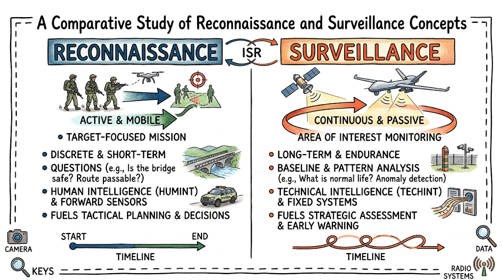
What Is Reconnaissance?
Reconnaissance is a focused mission conducted to collect information about the terrain, environmental conditions, civilian activities, or opposing forces within a specific area. It is an active, objective-driven activity executed by human assets, mechanical systems, or technical sensors. The primary characteristic of reconnaissance is its targeted nature; it is launched to answer explicit questions required for operational planning.
The purpose and objectives of reconnaissance center on reducing uncertainty before an operation begins. Designers of strategic plans use these missions to confirm or deny assumptions about an operational environment. For instance, a reconnaissance mission might determine if a specific bridge can support the weight of heavy transport vehicles or verify if an opposing force has occupied a particular ridge line. By answering these precise questions, reconnaissance helps mitigate risks to personnel and equipment.
What Is Surveillance?
Surveillance is the systematic, continuous, or periodic observation of a specific area, place, person, or activity. Unlike reconnaissance, which is typically a discrete, short-term mission, surveillance is designed for endurance and continuity. It establishes a baseline of normalcy for a monitored target and tracks changes, anomalies, or developments over extended periods.
The concept of continuous observation is foundational to effective surveillance. By maintaining persistent coverage over a location, such as a international border or a sensitive maritime strait, surveillance systems document patterns of life. This persistence allows intelligence analysts to understand what standard activity looks like, making any unusual behavior stand out immediately.
Reconnaissance vs Surveillance
While both activities are critical components of intelligence gathering, they differ significantly in execution, duration, and focus. The following table provides a comprehensive comparison of their unique characteristics.
Operational Comparison Matrix
| Aspect | Reconnaissance | Surveillance |
| Primary Purpose | To answer specific, immediate information requirements about a target or terrain. | To maintain continuous, systematic tracking and pattern analysis over time. |
| Duration | Short-term, discrete missions with a defined start and end point. | Long-term, continuous, and persistent over extended periods. |
| Information Collection Style | Active, exploratory, and often mobile seeking of information. | Passive, stationary, and persistent observation of an environment. |
| Operational Focus | Focused on a specific objective, such as a route, zone, or force. | Focused on a broad area, specific population, or static asset. |
| Typical Assets Used | Scout teams, fast-moving UAVs, forward ground sensors, and patrol vehicles. | Geostationary satellites, persistent long-endurance drones, fixed radar, and CCTV networks. |
| Decision Support Role | Supports immediate operational planning, maneuvering, and target engagement. | Supports long-term threat assessment, early warning, and strategic planning. |
| Scope | Narrow, deep, and highly specific to a particular geographical feature or force. | Broad, widespread, or tightly focused on long-term behavioral tracking. |
| Intelligence Value | Provides immediate ground truth and tactical clarity. | Provides baseline patterns of life, behavioral trends, and anomaly detection. |
Evolution of Reconnaissance and Surveillance
The methods used to observe an operational environment have evolved alongside human technology, shifting from basic physical observation to complex digital systems.
Historical Battlefield Scouting
For centuries, the primary tool for intelligence gathering was the physical scout. Mounted on horseback or moving on foot, scouts traveled ahead of main armies to seek out high ground, look for enemy campfires, and assess terrain passability. The scope of their observations was limited by the human eye and the physical distance a horse or soldier could travel in a day. The intelligence collected was highly subjective and dependent on the survival and return of the scout.
Aerial Reconnaissance
The advent of flight in the early 20th century transformed information gathering. During World War I, tethered balloons and early airplanes allowed observers to look over enemy lines, mapping trench networks and spotting artillery impacts. By World War II, dedicated aerial reconnaissance aircraft equipped with large-format cameras documented industrial infrastructure and troop concentrations, providing strategic-level intelligence that shaped global campaigns.
Satellite Observation
The Space Age introduced unprecedented observational capabilities. The deployment of optical and radar imaging satellites during the Cold War allowed nations to monitor foreign military installations without violating airspace restrictions. Satellites removed geographic barriers, making it possible to observe remote deserts, dense jungles, and oceanic expanses routinely, establishing the foundation for modern global surveillance systems.
Digital Intelligence Systems
The transition from film-based cameras to digital imaging and electronic sensors revolutionized the speed of data transmission. Digital systems enabled real-time or near-real-time data sharing, allowing information collected by a sensor thousands of miles away to be viewed instantly by analysts across the globe. This era also saw the rise of signals intelligence, where electronic emissions are intercepted and analyzed alongside visual data.
Modern ISR Concepts
Today, individual observation efforts are integrated into a single framework known as Intelligence, Surveillance, and Reconnaissance (ISR). Modern ISR concepts emphasize the networking of space-borne, aerial, maritime, and ground assets into a cohesive ecosystem. Instead of relying on a single photograph or scout report, modern decision-makers receive a synthesized picture built from multiple layers of sensor data, managed by advanced communication networks.
Types of Reconnaissance
Reconnaissance operations are categorized by their specific focus, geography, and objective. Each type requires a different planning approach and utilizes specialized assets.
Route Reconnaissance
Route reconnaissance focuses on a specific line of communication, such as a highway, railway, or waterway, and the terrain immediately adjacent to it. The goal is to collect detailed information on the travel route’s characteristics, including traffic capacity, bridge weight limits, overhead clearances, and potential ambush points. For example, before moving a convoy of humanitarian aid through a conflict zone, security forces conduct a route reconnaissance to ensure the path is free of obstacles and structurally capable of handling heavy cargo vehicles.
Area Reconnaissance
Area reconnaissance directs attention to a specific piece of terrain or a distinct locality, such as a town, a forest, or an industrial complex. The boundaries of an area reconnaissance are explicitly defined, and the asset is tasked with discovering all relevant features and threat activities within that specific footprint. A practical application is analyzing a deserted airfield to determine if it can be safely used for emergency landing operations.
Zone Reconnaissance
Zone reconnaissance is a broader and more demanding operation than area reconnaissance. It involves a thorough, systematic sweep of a large geographical zone bounded by specific grid lines. The objective is to identify all routes, terrain features, obstacles, and enemy forces within the entire zone. Because of its scale, zone reconnaissance requires multiple coordinated assets, such as a combination of satellite imagery, drone overflights, and ground patrols moving concurrently to map an unfamiliar region.
Force-Oriented Reconnaissance
Force-oriented reconnaissance shifts the focus away from geography and places it entirely on an opposing force. The objective is to locate, track, and determine the size, composition, and disposition of a specific group, regardless of where they move. This type of operation is essential when dealing with mobile elements that do not hold fixed positions, ensuring that planners understand the capabilities and movements of the group they are monitoring.
Terrain Reconnaissance
Terrain reconnaissance is an analytical study of the physical landscape, focusing on weather effects, soil composition, vegetation density, and water obstacles. It does not look for enemy forces but rather evaluates how the environment itself will impact movement. Engineers use terrain reconnaissance to identify suitable locations for constructing temporary bases, drilling for water, or establishing supply depots.
Types of Surveillance
Surveillance operations are defined by the medium or domain in which they operate, each requiring specific technical tools to maintain continuous observation.
Ground Surveillance
Ground surveillance involves the use of static observation posts, unattended ground sensors, and perimeter radar networks to monitor specific land areas. This type of surveillance is commonly used along international borders or around high-value facilities like power plants. Unattended sensors buried in the earth can detect footfalls or vehicular vibrations, alerting central monitoring stations to unauthorized movement without requiring a continuous human presence on the perimeter.
Aerial Surveillance
Aerial surveillance utilizes aircraft, helicopters, and long-endurance drones to maintain a watch over a region from above. By loitering at high altitudes, aerial surveillance platforms can monitor large swathes of land or sea for hours or days at a time. This method is frequently used in counter-smuggling operations, where aircraft monitor remote coastlines or desert tracks to identify unauthorized border crossings or illegal transport networks.
Maritime Surveillance
Maritime surveillance focuses on tracking vessel movements across oceans, seas, bays, and ports. It relies on coast-aligned radar, satellite monitoring, and automatic identification systems (AIS) broadcast by ships. Maritime surveillance is critical for ensuring freedom of navigation, enforcing economic exclusion zones, tracking illegal fishing fleets, and protecting underwater communication cables from malicious interference.
Electronic Surveillance
Electronic surveillance involves the monitoring and interception of non-visual signals, including radio frequencies, radar emissions, and digital communications. By scanning the electromagnetic spectrum, electronic surveillance systems can identify the location and type of communication equipment operating in an area. This allows analysts to map command structures and detect increases in communication volume, which often precede major movements or policy shifts.
Satellite Surveillance
Satellite surveillance provides global coverage by positioning optical, thermal, and radar sensors in orbit around the Earth. Geostationary satellites remain fixed over a specific point on the equator, providing uninterrupted monitoring of a hemisphere, while polar-orbiting satellites circle the globe to capture high-resolution imagery of different regions daily. This form of surveillance is vital for verifying international treaties, tracking large-scale environmental changes, and monitoring strategic industrial developments worldwide.
Technologies Used in Reconnaissance and Surveillance
The effectiveness of modern observation depends heavily on the integration of advanced hardware and software technologies.
+-----------------------------------------------------------------+
|                    MODERN ISR SENSOR LAYERS                     |
+-----------------------------------------------------------------+
|                                                                 |
|   [Space Layer]        Satellites (Optical, Radar, Thermal)     |
|                              |                                  |
|   [Aerial Layer]       UAVs / High-Altitude Drones / Aircraft   |
|                              |                                  |
|   [Ground/Sea Layer]   Sensors / Fixed Radar / Ground Teams     |
|                                                                 |
+-----------------------------------------------------------------+
Drones and UAVs
Unmanned Aerial Vehicles (UAVs), ranging from small hand-launched systems to large, high-altitude platforms, have democratized aerial intelligence. Drones remove the pilot from danger, allowing systems to operate in high-threat environments or fly extended missions that would exhaust a human crew. Equipped with stabilized camera gimbals, drones transmit live video feeds directly to field personnel and strategic headquarters simultaneously.
Sensors
Modern surveillance relies on an array of specialized sensors that detect signatures beyond human vision. Acoustic sensors listen for specific frequencies, such as engine noise or mechanical movement. Seismic sensors detect vibrations in the ground, while magnetic sensors track the movement of large metallic objects like vehicles. These devices are often low-profile and energy-efficient, allowing them to remain operational in remote areas for months at a time.
Satellite Systems
Satellite technology has evolved to include Synthetic Aperture Radar (SAR), which can penetrate cloud cover, dense foliage, and darkness to produce detailed images of the ground. This ensures that observation can continue regardless of adverse weather conditions or seasonal light variations, providing a reliable source of global oversight that cannot be obscured by smoke, storms, or nightfall.
Radar Systems
Radar (Radio Detection and Ranging) systems emit radio waves and measure the reflections to determine the distance, speed, and direction of objects. Ground-moving target indicator (GMTI) radar allows operators to distinguish moving vehicles from static terrain features over vast distances. Air defense radars continuously scan the skies to track aircraft and incoming projectiles, serving as a primary pillar of early warning networks.
Imaging Technologies
Beyond standard digital photography, modern systems employ infrared (IR) and thermal imaging to detect heat signatures. Because living bodies and running machinery emit heat, thermal imaging allows observers to detect activity in complete darkness or through camouflage. Hyperspectral imaging goes a step further, analyzing a wide spectrum of light to identify the specific material composition of objects, making it possible to distinguish between natural vegetation and painted decoy structures.
Communication Networks
The data gathered by sensors and imaging systems is only useful if it can be transmitted securely to decision-makers. High-bandwidth satellite communications, encrypted data links, and tactical mesh networks ensure that large volumes of video and sensor data travel securely without interception or disruption. These networks connect the isolated sensor to a global audience of analysts, enabling rapid collaboration and verification.
Intelligence, Surveillance, and Reconnaissance (ISR)
The modern integration of these functions into a single system is known as ISR. This concept ensures that information collection is not an isolated event but a continuous cycle that turns observations into actionable knowledge.
What ISR Means
ISR is an integrated capability that tasks assets to collect, process, and exploit information to support operational decisions. It recognizes that reconnaissance and surveillance are not independent activities; rather, they are complementary parts of a larger intelligence framework. By combining the targeted focus of reconnaissance with the persistent oversight of surveillance, ISR creates a comprehensive picture of the operational space.
Components of ISR
The ISR framework is built upon three pillars:
- Intelligence: The final product derived from the analysis of collected data, providing context, meaning, and predictive value.
- Surveillance: The persistent observation mechanism that monitors targets and tracks environmental changes over time.
- Reconnaissance: The targeted deployment of assets to answer specific questions or explore unknown areas.
The Information Lifecycle
The journey from a raw observation to a strategic decision follows a structured sequence known as the information lifecycle:
[ Collection ] ---> [ Processing ] ---> [ Exploitation ] ---> [ Dissemination ]
- Collection: Sensors, drones, satellites, or personnel gather raw data from the operational environment.
- Processing: Raw data is converted into a readable format, such as developing radar data into an image or translating a foreign radio broadcast.
- Exploitation: Analysts review the processed data, identifying key pieces of information, cataloging targets, and comparing findings with existing records.
- Dissemination: The finalized intelligence product is delivered to decision-makers in a clear, concise format, ensuring it arrives in time to influence choices.
The Intelligence Analysis Process
Intelligence analysis is the critical thinking phase where processed data is evaluated for credibility, relevance, and meaning. Analysts look for patterns, connect separate pieces of information, and assess the reliability of the source. The goal is to answer not just what is happening, but why it is happening and what it means for future operations, transforming raw observations into strategic foresight.
Real-World Applications
The principles of reconnaissance and surveillance extend far beyond traditional defense planning, serving critical roles across a wide range of civilian, humanitarian, and security contexts.
Military Operations
In conventional defense contexts, reconnaissance and surveillance reduce the risk of surprise. They allow security forces to map defensive positions, identify logistical supply lines, and monitor troop movements. This baseline understanding helps prevent miscalculations and ensures that defensive or deterrent actions are proportionate and accurately targeted.
Border Security
Nations utilize integrated surveillance systems to manage and secure long international borders. Ground radars, thermal cameras, and aerial drone patrols monitor remote border regions to detect illegal crossings, human trafficking, and contraband smuggling. By providing early warnings of border approaches, these systems allow border enforcement agencies to deploy personnel efficiently to specific locations rather than patrolling vast spaces blindly.
Maritime Monitoring
The global maritime commons rely on surveillance to ensure safe trade and resource protection. Satellites and long-range aircraft monitor shipping lanes to protect commercial vessels from piracy, detect illegal ship-to-ship fuel transfers, and identify vessels responsible for oil spills. Maritime surveillance also protects marine sanctuaries by tracking unauthorized commercial fishing fleets operating in restricted waters.
Disaster Response
Following natural disasters such as earthquakes, hurricanes, or wildfires, reconnaissance operations are launched immediately to assess damage. Satellites and drones map affected areas, identifying collapsed bridges, blocked roads, and flooded neighborhoods. This rapid assessment allows emergency managers to direct search-and-rescue teams to the hardest-hit communities and plan safe delivery routes for food, water, and medical supplies.
Peacekeeping Missions
International peacekeeping bodies use surveillance to monitor ceasefire agreements and demilitarized zones. By deploying cameras, radar systems, and aerial observers along separation lines, peacekeepers can independently verify compliance with international treaties. If a violation occurs, the documented surveillance data provides objective evidence that can be used in diplomatic forums to de-escalate tensions before conflict resumes.
Benefits of Reconnaissance and Surveillance
Investing in robust observation systems delivers substantial advantages to any organization tasked with managing risk or security.
Better Situational Awareness
The primary benefit of systematic observation is a comprehensive understanding of the environment. Decision-makers are not forced to rely on guesswork or outdated maps; they have access to real-time or recent depictions of the operational space. This clarity includes knowing where friendly assets are, where potential threats reside, and how the terrain and weather will influence upcoming activities.
Improved Decision-Making
Access to high-quality intelligence accelerates and refines the decision-making process. When leaders understand the layout, capabilities, and intentions of other actors in the region, they can make informed, deliberate choices. This reduces the likelihood of knee-jerk reactions, helps avoid costly strategic errors, and allows organizations to maintain the operational initiative.
Risk Reduction
By identifying hazards, obstacles, and threats in advance, reconnaissance and surveillance protect human lives and expensive infrastructure. A reconnaissance mission that identifies an unstable hillside or an insurgent ambush position allows a team to bypass the danger entirely. In security operations, knowing the exact layout of a hostile location before entry minimizes casualties for all parties involved.
Operational Effectiveness
When an organization operates with accurate intelligence, its actions are highly focused and effective. Instead of searching a massive forest for an elusive target, surveillance systems can pinpoint the exact location, allowing a precise response. This precision ensures that objectives are achieved quickly, with minimal collateral damage or unintended disruptions to surrounding populations.
Resource Optimization
No organization has unlimited personnel, equipment, or time. Surveillance allows for efficient resource allocation by identifying where assets are needed most. If automated sensors show that a particular sector of a border is quiet, security forces can be reassigned to sectors experiencing higher levels of unauthorized activity, maximizing the impact of available resources.
Challenges and Limitations
Despite significant technological advancements, reconnaissance and surveillance operations face enduring challenges that can limit their effectiveness.
Information Overload
Modern sensors produce massive volumes of data every second. High-definition video feeds, radar logs, electronic intercepts, and satellite images can easily overwhelm intelligence networks. The challenge is no longer a lack of data, but rather the difficulty of sorting through thousands of terabytes of information to find the few critical pieces of actionable intelligence. Without sufficient analysts or automated filtering tools, important indicators can be missed.
Environmental Constraints
Nature remains a major obstacle to observation. Heavy cloud cover, dense fog, torrential rain, and sandstorms can blind optical cameras and disrupt laser-guided sensors. Similarly, dense jungle canopies or deep urban canyons can obscure ground movements from aerial and satellite view, providing physical cover that technical systems struggle to penetrate.
Data Accuracy Concerns
Not all collected data is accurate or truthful. Opposing forces frequently employ deception techniques, such as constructing decoy vehicles, using camouflage, or broadcasting false radio signals to mislead observers. Analysts must constantly cross-reference data sources to avoid falling victim to misinformation campaigns designed to distort their situational awareness.
Technology Dependence
Modern ISR operations rely heavily on complex technology, making them vulnerable to technical failures, cyberattacks, and electronic jamming. If a satellite communication link is severed or a drone’s GPS signal is jammed, an entire operational network can lose its sight instantly. Over-reliance on technical systems can leave organizations vulnerable if they neglect fundamental ground-based observation skills.
Communication Challenges
Gathering information is pointless if it cannot be shared with those who need it. Bandwidth limitations in remote parts of the world can slow down the transmission of large files, such as high-resolution video or radar maps. Furthermore, organizational silos and differing security classification levels can prevent critical intelligence from being shared quickly between different agencies or international allies during joint operations.
Future Trends
The field of reconnaissance and surveillance is undergoing rapid transformation, driven by emerging technologies that promise to reshape how data is collected and analyzed.
Artificial Intelligence in ISR
The integration of Artificial Intelligence (AI) and machine learning is directly addressing the challenge of information overload. AI algorithms can scan thousands of hours of surveillance video or thousands of satellite images to automatically detect specific objects, such as vehicles, ships, or structural changes. By filtering out normal baseline activity, AI flags anomalies for human review, dramatically speeding up the exploitation phase of the information lifecycle.
Autonomous Systems
Future surveillance will rely increasingly on fully autonomous air, ground, and maritime drones. These systems will be capable of navigating, managing their power consumption, and executing collection missions over months or years without direct human intervention. Autonomous underwater vehicles (AUVs), for example, will persistently monitor oceanic baselines, tracking underwater pipeline integrity and maritime security independently.
Advanced Sensors
Sensor technology is becoming smaller, more sensitive, and more energy-efficient. Quantum sensors, currently in development, promise to detect subtle changes in gravity and magnetic fields with unprecedented precision, potentially making it possible to locate buried structures or submerged submarines easily. Additionally, the development of flexible, micro-scale sensors will allow for the deployment of widespread, low-profile monitoring networks.
Real-Time Analytics
The future lies in the transition from near-real-time data delivery to instantaneous edge computing and analysis. Sensors will possess the onboard processing power to analyze data at the point of collection and transmit the finalized insight rather than sending massive raw files back to a central server. This shift will ensure that field personnel receive immediate alerts regarding threats in their immediate vicinity.
Multi-Domain Operations
As security challenges span across land, sea, air, space, and cyberspace, future ISR frameworks must operate across all these domains simultaneously. Multi-domain operations require seamless data integration, where a cyber-intercept can automatically task a satellite to image a specific coordinate, while a ground sensor triggers an autonomous drone to investigate the area. This level of interconnectivity will create a unified, responsive observation network.
Key Takeaways
- Reconnaissance is an active, targeted, and time-bound mission designed to answer specific questions about terrain, conditions, or forces in a particular area.
- Surveillance is a passive, continuous, and long-term activity focused on systematic observation to track patterns of life and detect environmental changes.
- The Key Difference lies in duration, focus, and methodology: reconnaissance explores to discover new ground truth, while surveillance monitors to identify variations from an established baseline.
- Operational Value is found in the reduction of uncertainty, enabling leaders to make informed choices, minimize risks, optimize limited resources, and enhance overall safety.
FAQ Section
1.What is reconnaissance in military operations?
Reconnaissance is a focused mission conducted to obtain specific information about the activities, resources, or terrain of a potential threat or area of interest. It is typically a short-term, active exploration carried out prior to or during operations to provide direct support for tactical and strategic planning.
2.What is surveillance?
Surveillance is the systematic and continuous observation of a person, place, object, or activity over an extended duration. Its primary goal is to establish a behavioral baseline, collect ongoing data, and provide early warning of any changes or unusual activity within the monitored environment.
3.What is the difference between reconnaissance and surveillance?
The main difference is duration and focus. Reconnaissance is a temporary, active mission designed to answer specific questions about an unknown area or threat. Surveillance is a long-term, continuous, and often passive observation meant to monitor known locations or targets over time to detect patterns and changes.
4.What does ISR stand for?
ISR stands for Intelligence, Surveillance, and Reconnaissance. It represents an integrated system of systems that coordinates the collection, processing, exploitation, and dissemination of information from various sources to provide decision-makers with comprehensive situational awareness.
5.What technologies are used for surveillance?
Surveillance utilizes a wide array of tools, including high-resolution optical satellites, Synthetic Aperture Radar (SAR), thermal and infrared imaging systems, unmanned aerial vehicles (UAVs), unattended ground sensors, and electronic signal interception equipment.
6.How do drones support reconnaissance missions?
Drones support reconnaissance by flying ahead of ground forces to capture real-time aerial imagery and video of routes or areas of interest. This allows teams to identify potential hazards, obstacles, or threat positions from a safe distance without risking human lives in unexplored territory.
7.Why is situational awareness important?
Situational awareness is critical because it gives leaders a clear, accurate understanding of their current environment, including threats, terrain features, and operational limitations. This understanding reduces the risks associated with uncertainty and enables more effective and accurate decision-making.
8.What are the major challenges in intelligence collection?
The primary challenges include information overload from handling too much raw data, environmental constraints like bad weather and heavy foliage, intentional deception by adversaries, technical vulnerabilities such as cyberattacks or jamming, and communication delays in remote regions.
9.How does satellite surveillance work?
Satellite surveillance works by using orbital sensors to capture data from Earth. Optical satellites take high-resolution photographs, thermal sensors detect heat emissions, and radar systems bounce radio signals off the surface to map terrain, operating through darkness and cloud cover to provide global visibility.
10.What is the future of reconnaissance and surveillance?
The future centers on the integration of artificial intelligence to automate data analysis, the use of highly autonomous unmanned systems for long-endurance monitoring, the development of more precise quantum sensors, and the creation of unified multi-domain networks that share data instantly.
Conclusion
Reconnaissance and surveillance are foundational pillars of modern security, stability, and operational planning. By transforming unknown environments into structured, understandable data, these activities remove the guesswork from high-stakes decision-making. Whether executing a targeted reconnaissance mission to verify the safety of a transit route or maintaining long-term surveillance over an international border, the insights gained are vital for protecting assets and ensuring mission success.
As technology continues to advance, the traditional boundaries of observation are expanding. The integration of artificial intelligence, autonomous drone networks, and resilient satellite constellations into unified ISR frameworks ensures that information can be collected and analyzed faster than ever before. These developments do not change the core purpose of observation, but they vastly enhance its reach, persistence, and accuracy, making security operations more responsive to emerging global challenges.