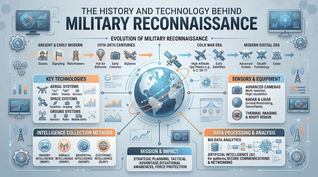
Before any military force can make a good decision, it needs information. It needs to know what the land looks like, who is nearby, and how conditions are changing. Without this information, even a strong force is acting blindly.
This need for reliable information is not new. Armies have searched for ways to understand their surroundings for thousands of years. The methods have changed a lot, but the basic goal has stayed the same.
This article looks at what military reconnaissance means, how it developed, and how modern technology supports it today.
What Is Military Reconnaissance?
Military reconnaissance is the process of collecting information about an area, situation, or opposing force to support decision-making.
In simple terms, it means going out or using tools to learn something specific that a military force needs to know.
Military education sources describe reconnaissance and information activities as part of understanding the operational environment and supporting military decision-making. It’s less about action, and more about understanding.
Why Is Reconnaissance Important?
Information plays a central role in military planning.
Reconnaissance broadly helps with:
- Understanding an area – Knowing the land, roads, and structures nearby.
- Learning about conditions – Weather, visibility, and other factors that affect operations.
- Supporting planning – Giving leaders the facts they need to plan.
- Confirming information – Checking whether earlier reports are still accurate.
- Reducing uncertainty – Filling in gaps in knowledge.
- Improving situational awareness – Building a clearer overall picture.
Without good information, plans are built on guesses instead of facts.
Reconnaissance vs Surveillance
These two terms often get confused, but they mean different things.
Reconnaissance
This usually means actively gathering information for a specific need. It often has a clear goal and a defined period of time.
Surveillance
This usually means watching an area, activity, or subject over time, often continuously.
Simple example: Sending someone out once to check road conditions is closer to reconnaissance. Watching the same road continuously over several days is closer to surveillance.
Historical sources also draw this same distinction: reconnaissance involves actively going out to look for specific information, while surveillance can involve sustained watching over time.
A Short History of Military Reconnaissance
Reconnaissance has changed a great deal across history.
- Ancient armies – Relied on scouts and local knowledge to understand terrain and enemy movement.
- Medieval warfare – Used mounted riders and messengers to gather and share information quickly.
- Napoleonic period – Cavalry units often carried out early reconnaissance roles ahead of larger forces.
- World War I – Aircraft began to change reconnaissance, offering a view from above for the first time at scale.
- World War II – Aerial photography and radar became widely used tools.
- Cold War – Satellite technology and advanced aircraft expanded reconnaissance far beyond the battlefield.
- Modern military systems – Today’s tools combine satellites, drones, sensors, and data analysis together.
Each period added new tools, but the core purpose never changed: understanding the situation before acting.
Early Reconnaissance Methods
Long before modern technology, armies relied on simpler methods.
- Scouts – Individuals sent ahead to observe and report back.
- Messengers – People who carried information between different groups.
- Maps – Early maps helped commanders understand terrain, even if imperfect.
- Human observation – Simply watching and reporting what was seen.
- Mounted reconnaissance – Riders who could cover ground faster than those on foot.
- Local information – Knowledge from people already familiar with an area.
These methods were slow by today’s standards, but they served the same basic purpose reconnaissance serves now.
Aerial Reconnaissance
Aircraft changed reconnaissance in a major way.
Before aircraft, most information came from the ground. Once aircraft became available, forces could observe much larger areas from above.
Key developments included:
- Observation aircraft – Early planes used simply to look down and report.
- Aerial photography – Cameras mounted on aircraft to capture images of the ground below.
- Mapping – Aerial images helped build more accurate maps.
- Later sensor systems – Over time, aircraft carried more advanced tools beyond simple cameras.
The National Air and Space Museum notes that reconnaissance aircraft were used to look for enemy activity and gather information from the air during World War I. This was one of the first major shifts in how military information was collected.
Modern Reconnaissance Technology
Today’s reconnaissance relies on a wide range of tools.
Broad categories include:
- Satellites – Provide images and data from high above the Earth.
- Aircraft – Continue to play a role in modern information gathering.
- Uncrewed aerial systems – Drones that can observe areas without a pilot on board.
- Cameras – Capture visual details of an area.
- Radar – Detects objects and movement using radio waves.
- Thermal sensors – Detect heat differences, useful in low visibility.
- Electronic sensors – Pick up various types of signals.
- Mapping systems – Build detailed pictures of terrain and structures.
- Data analysis – Helps make sense of large amounts of collected information.
Each of these tools contributes a different piece to the overall picture military planners need.
Types of Military Reconnaissance
Reconnaissance is generally grouped into a few broad categories.
Visual Reconnaissance
Collecting information through direct visual observation or imagery.
Aerial Reconnaissance
Using aircraft or other airborne systems to collect information from above.
Ground Reconnaissance
Collecting information about terrain and conditions directly from the ground.
Technical Reconnaissance
Using technical systems and sensors to gather information.
Electronic Reconnaissance
Collecting information from electronic signals, in broad terms.
Military education programs commonly introduce related disciplines such as HUMINT, IMINT, SIGINT, MASINT, and OSINT when discussing intelligence and reconnaissance topics. We’ll look at a few of these next.
Role of Human Intelligence
Human Intelligence, often called HUMINT, involves information gathered from people.
In broad terms, this means learning information through human sources or interactions, rather than through machines or sensors.
This article keeps this topic general and educational. It does not cover interrogation methods, recruitment practices, or specific collection techniques.
Role of Imagery Intelligence
Imagery Intelligence, or IMINT, deals with information gathered from images.
Images, whether from aircraft, satellites, or other sources, can help analysts understand places, objects, and changes over time.
Simple example: Comparing images of the same area taken months apart can show new construction or changes in land use.
This section stays focused on the general concept, not on specific targeting or identification methods.
Role of Signals Intelligence
Signals Intelligence, or SIGINT, relates broadly to information gathered from signals.
At a basic level, this means information that comes from various types of electronic signals, rather than from images or human sources.
This article does not cover interception methods, technical equipment, or specific procedures, since those fall outside an educational, high-level overview.
Role of Open-Source Information
Open-Source Intelligence, or OSINT, refers to information collected from publicly available sources.
This can include:
- Public reports
- Maps
- News articles
- Publicly shared images
- Government publications
Publicly available information can sometimes help build a broader picture when combined with other sources. This is a widely discussed area in general intelligence education, well beyond just military contexts.
Role of Maps and Terrain Information
Understanding the land itself matters a great deal in military planning.
Terrain information generally covers:
- Roads and pathways
- Rivers and bodies of water
- Mountains and elevation
- Built-up or urban areas
- Weather patterns
- General geography of a region
This kind of information helps build a broad understanding of an area, without getting into specific movement or tactical planning.
Sensors Used in Modern Reconnaissance
Modern reconnaissance often relies on a mix of sensor types.
- Optical cameras – Capture standard visual images.
- Infrared sensors – Detect heat signatures, useful at night or in poor visibility.
- Radar – Detects objects and movement using reflected radio waves.
- Thermal imaging – Shows temperature differences across a scene.
- Other electronic sensors – Cover various additional types of signals.
Different sensors provide different kinds of information, and combining them often gives a more complete picture than any single sensor alone.
Role of Drones and Uncrewed Systems
Uncrewed aerial systems, commonly known as drones, have expanded reconnaissance capabilities significantly.
Broadly, these systems support:
- Aerial imagery collection
- Mapping large areas
- Remote observation without a pilot present
- General data collection from above
Drones have made certain types of aerial information gathering more accessible and flexible than traditional aircraft alone.
Satellite Reconnaissance
Satellites support reconnaissance from a much higher vantage point than aircraft.
Broad uses include:
- Earth imagery – Capturing images of large areas of land.
- Mapping – Supporting the creation of detailed maps.
- Environmental observation – Tracking natural changes over time.
- Monitoring changes – Comparing images across different time periods.
Satellites allow for a wide, high-level view that ground or aerial methods alone cannot provide.
Data Analysis in Modern Reconnaissance
Collecting information is only the first part of the process. Making sense of it matters just as much.
Analysts generally work to:
- Organize the information collected
- Compare different sources against each other
- Check how reliable each source is
- Look for patterns across the data
- Build a broader, more complete picture
Raw data on its own isn’t very useful until it’s properly reviewed and understood.
Importance of Accurate Information
Inaccurate information can create real problems for decision-making.
Issues that can arise include:
- Wrong assumptions being made
- Conflicting reports causing confusion
- Outdated information leading to poor choices
- Decisions based on incomplete pictures
This is why information typically gets checked against multiple, reliable sources before it’s used in planning.
Reconnaissance and Situational Awareness
Situational awareness means having a clear understanding of a current situation.
Reconnaissance contributes to this by helping answer questions such as:
- What is currently happening?
- Where is it happening?
- How are conditions changing over time?
- What information is still missing?
Good situational awareness comes from combining many small pieces of information into one clearer picture.
Reconnaissance in Disaster Response and Civilian Uses
Many reconnaissance technologies also serve peaceful, civilian purposes.
Examples include:
- Disaster mapping – Understanding the scale of damage after an event.
- Search and rescue – Locating people who need help.
- Flood assessment – Tracking how floodwaters spread.
- Wildfire monitoring – Watching fire movement from above.
- Damage assessment – Reviewing the extent of destruction after a disaster.
- Emergency planning – Helping responders plan next steps.
The same cameras, sensors, and satellites used in military reconnaissance often play a helpful role in disaster response and humanitarian work.
Challenges of Modern Reconnaissance
Modern reconnaissance faces its own set of challenges.
- Large amounts of data – More sensors mean more information to process.
- False information – Not every report or image tells the full truth.
- Sensor limits – Every sensor has limitations in what it can detect.
- Weather – Poor conditions can affect visibility and sensor performance.
- Technical failures – Equipment doesn’t always work as expected.
- Privacy concerns – Collecting information raises real privacy questions.
- Information overload – Too much data can be as hard to manage as too little.
- Need for human review – Technology alone can’t fully replace careful analysis.
These challenges show that reconnaissance isn’t a simple, solved problem, even with advanced tools available today.
Ethics and Legal Considerations
Reconnaissance raises important questions that go beyond just technology.
These include considerations around:
- Privacy – How information about people and places gets collected and used.
- Civilian protection – Ensuring information gathering doesn’t put civilians at risk.
- Data use – How collected information gets stored, shared, and applied.
- International law – Rules that govern military activities across borders.
- Responsible technology use – Using powerful tools thoughtfully and within limits.
This article doesn’t offer legal advice. These are simply important themes worth understanding as part of a broader education on this topic.
Future of Military Reconnaissance
Reconnaissance technology continues to develop in several directions.
Broad trends include:
- AI-assisted data analysis, helping process large amounts of information faster
- Better sensors with improved accuracy and range
- More autonomous systems handling routine collection tasks
- Continued advances in satellite technology
- Faster overall data processing
- Systems that combine multiple sources of information together
These trends point toward more capable tools, though exactly how they develop remains to be seen.
Simple Comparison Table
| Type | Simple Meaning | General Information Collected |
|---|---|---|
| Ground Reconnaissance | Information gathered from the ground | Terrain and conditions |
| Aerial Reconnaissance | Information gathered from the air | Images and area information |
| Imagery Intelligence | Information from images | Visual details |
| Signals Intelligence | Information from signals | Signal-related information |
| Human Intelligence | Information from people | Human-sourced information |
| Open-Source Intelligence | Information from public sources | Publicly available information |
FAQs
1. What is military reconnaissance in simple terms?
It’s the process of collecting information about an area, situation, or force to support military decision-making.
2. Why does reconnaissance matter so much in military operations?
It helps reduce uncertainty and gives planners the facts they need, instead of relying on guesses.
3. What’s the difference between reconnaissance and surveillance?
Reconnaissance usually means actively gathering information for a specific need, while surveillance means watching something continuously over time.
4. What are the main types of military reconnaissance?
Common types include visual, aerial, ground, technical, and electronic reconnaissance.
5. What does aerial reconnaissance involve?
It involves using aircraft or airborne systems to gather information about an area from above.
6. What is imagery intelligence used for?
It uses images, often from aircraft or satellites, to help analysts understand places, objects, and changes over time.
7. What does human intelligence generally involve?
It broadly refers to information gathered through people, rather than through sensors or technical systems.
8. How are satellites used in reconnaissance?
Satellites capture imagery and data from high above the Earth, supporting mapping and monitoring changes over time.
9. How have drones changed reconnaissance?
Drones have expanded the ability to gather aerial information without needing a pilot on board.
10. What challenges does modern reconnaissance face?
Challenges include managing large amounts of data, sensor limitations, weather effects, and the need for careful human review.
Conclusion
Military reconnaissance has always served one core purpose: helping forces understand their surroundings before making decisions. What started with scouts and messengers has grown into a mix of satellites, aircraft, drones, and advanced sensors.
The tools have changed dramatically, but the underlying need for accurate, timely information hasn’t. Understanding this basic concept helps make sense of how modern defense technology and historical military strategy connect.